Style | StandardCards

OpenStreetMap Blogs

Saturday, 26. October 2019

ШТОСМ

Главный вопрос OpenStreetMap

Сейчас в Призрене, Косово, идёт конференция State of the Map SEE (юго-восточной Европы). Видеозаписей не будет: она по-настоящему локальная, для той пары сотен человек, кто понимает английский. После моего доклада появились несколько идей, которые стоило записать. Если хотите контекст — следите за телеграм-каналами @foss4g_ru и @shtosm.

Рассказал про OpenStreetMaps во множественном числе.

Сейчас в Призрене, Косово, идёт конференция State of the Map SEE (юго-восточной Европы). Видеозаписей не будет: она по-настоящему локальная, для той пары сотен человек, кто понимает английский. После моего доклада появились несколько идей, которые стоило записать. Если хотите контекст — следите за телеграм-каналами @foss4g_ru и @shtosm.

Рассказал про OpenStreetMaps во множественном числе. Втопил за многоязычность и разнообразие среди участников — и понимание, что у нас не одна OpenStreetMap с единым всемирным сообществом, а тысяча отдельных OSM с тысячью маленьких и больших сообществ, у каждого из которых свои практики тегирования и мнения о полноте карты. Я не понимаю, как здесь, в Косово, отметят свои кебабные рестораны на карте их владельцы, когда они не могут даже узнать про OSM (сайт этой конференции — только на английском) и узнать его правила (перевода вики на албанский нет).

Сейчас с Феликсом классно обсудили эти наблюдения. Спросил у него про нападки на Missing Maps. Европейцы замечали, что от всей этой инициативы веет колониализмом: белые мужчины решают, как выглядеть карте Африки и Азии. С другой стороны, карта колониальна по своей природе: ты идёшь в соседний двор и решаешь, как ему выглядеть на карте, что должно там быть и что нет. Карта — это власть; нельзя делать карту и не иметь власти. Цель подобных конференций — поделиться этой властью, дать её как можно большему количеству людей.

Но, опять же, среди слушателей нет владельцев кебабных. Они не поймут доклады, хотя среди них есть очень доходчивые ликбезы, потому что они на английском. Нужно ли им это? Закрадывается странная мысль, что может, пусть они жарят свои кебабы, карта им ни к чему. Поэтому их нет в OSM. Это опасно походит на поверье десятилетней давности, что женщин в технических профессиях мало, потому что это не женское дело, это им не интересно. Стыдная мысль, даже писать её неловко.

Другое, о чём мы задумались, — OpenStreetMap как средство получения и передачи знаний. Ты не рисуешь домики, а узнаёшь, как устроена карта, как проекция влияет на прямоту углов, как спутниковые снимки соотносятся с картой. Ты получаешь важные знания и даже не обращаешь на это внимание. Потенциальные картографы в деревнях, охваченных Missing Maps, лишаются этого: всё нарисовано за них. Для компаний и кампаний OpenStreetMap — это данные. Нужно больше данных, нужны свежие данные. Но людям нужны не данные, а знания. Люди — особенно люди из далёких стран — предпочтут научиться, предпочтут освоить удочку, а не получить рыбу. Закрашивая карту из лучших побуждений, мы лишаем этих людей знания.

Важная часть обучения картографии — ошибки. Придя в проект, ты рисуешь кривые домики, выбираешь глупые теги (я помню про свои juridical_faces) и забываешь соединить улицы. Потом понимаешь, в чём ошибка. Придумываешь свои теги, обращаешь внимание на мелочи, которые не интересуют других: на полосы обгона, кусты вдоль дороги, люки. Быть в OpenStreetMap на заре его становления было классно: ты двигался наощупь и узнавал многое в процессе.

Сейчас если ты сделаешь ошибку, тебе в личку быстро придёт кто-то из сотни валидаторов и сообщит о ней. Может, даже отругает. Всё стандартизировано, везде валидаторы. Карту используют в Facebook, Mapbox, Microsoft, Apple. Она должна быть однообразна и корректна. У современных новичков в OSM нет права на ошибку. Они приходят и становятся частью даже не сообщества, а армии картографов, где всё должно быть ровно, параллельно и покрашено в уставные цвета. Из проекта уходит игра и приходят задачи. А игра — это лучший способ получить знания. Корпорации и опытные картографы лишают участников знаний в обмен на большие и качественные данные.

Непонятно, что с этим делать. Возможно, это лишь моментное чувство, а OpenStreetMap, как мы знаем, не оперирует моментом: на него нужно смотреть через десять, пятьдесят лет. ML и AI, которые никогда не приносят новых знаний, как пришли, так и уйдут. Может, мы поймём, что OSM идёт не туда, и сделаем альтернативу. Может, мы запретим массовые правки. Или запретим препятствовать им. В ближайшие годы нам придётся ответить, что такое OpenStreetMap. Данные или карта? Игровая площадка или галеры? Средство общения или проект? Польза или сообщество? Наш совместный ответ определит будущее проекта — и, конечно, оно не понравится никому в любом случае.


OpenStreetMap User's Diaries

Projeto de Mapeamento de CEP´S da Cidade do Recife/PE com Base do CNEFE.

Esse Projeto foi Baseado nos dados do CNEFE e aplicado na Cidade do Recife em Ruas e Avenidas dos Bairros do Recife, a base de CEP do CNEFE pode ser encontrada no link;. ftp://ftp.ibge.gov.br/Censos/Censo_Demografico_2010/Cadastro_Nacional_de_Enderecos_Fins_Estatisticos/PE/ (Cadastro Nacional de Endereços para Fins Estatísticos).

♦ Consulta Cep no Overpass; overpass-turbo.eu/s/CnQ

Esse Projeto foi Baseado nos dados do CNEFE e aplicado na Cidade do Recife em Ruas e Avenidas dos Bairros do Recife, a base de CEP do CNEFE pode ser encontrada no link;. ftp://ftp.ibge.gov.br/Censos/Censo_Demografico_2010/Cadastro_Nacional_de_Enderecos_Fins_Estatisticos/PE/ (Cadastro Nacional de Endereços para Fins Estatísticos).

Consulta Cep no Overpass; https://overpass-turbo.eu/s/CnQ

Arquivos PDF dos CEP´S usado no Projeto Mapeia Recife. https://mega.nz/#!HpIjRYgC!UbxkNWLHGLe4N2dAMlD2tCgbNSwJG6SbR-i6dsZGAPw

Consulta Cep´s de Ruas e Avenidas do Recife no Site do Geofabrik. https://tools.geofabrik.de/osmi/

Pagina do Projeto Mapeia Recife. https://guiaosmbr.webnode.com/l/projeto-de-mapeamento-de-cep%C2%B4s-da-cidade-do-recife-pe-com-base-do-cnefe-projeto-mapeia-cep/

Os Cep´s do OSM pode ser Consultado no App OsmAnd Android https://play.google.com/store/apps/details?id=net.osmand&hl=pt_BR

Conheça nosso Grupo no Telegram; https://web.telegram.org/#/im?p=@osm_pernambuco

Um Forte Abraço,

Raphaelmirc Recife/PE.

Friday, 25. October 2019

OpenStreetMap User's Diaries

Footpath and Bridleway tagging in England and Wales - a personal view

I was prompted to write this because of a few discussions over the last couple of months - people talking about the default tags on various OSM elements, reactions to Amazon mappers’ additions of “last mile” service roads and discussions about how to tag England and Wales’ public rights of way network.

This is very much a personal view and one that’s very “England and Wales” ce

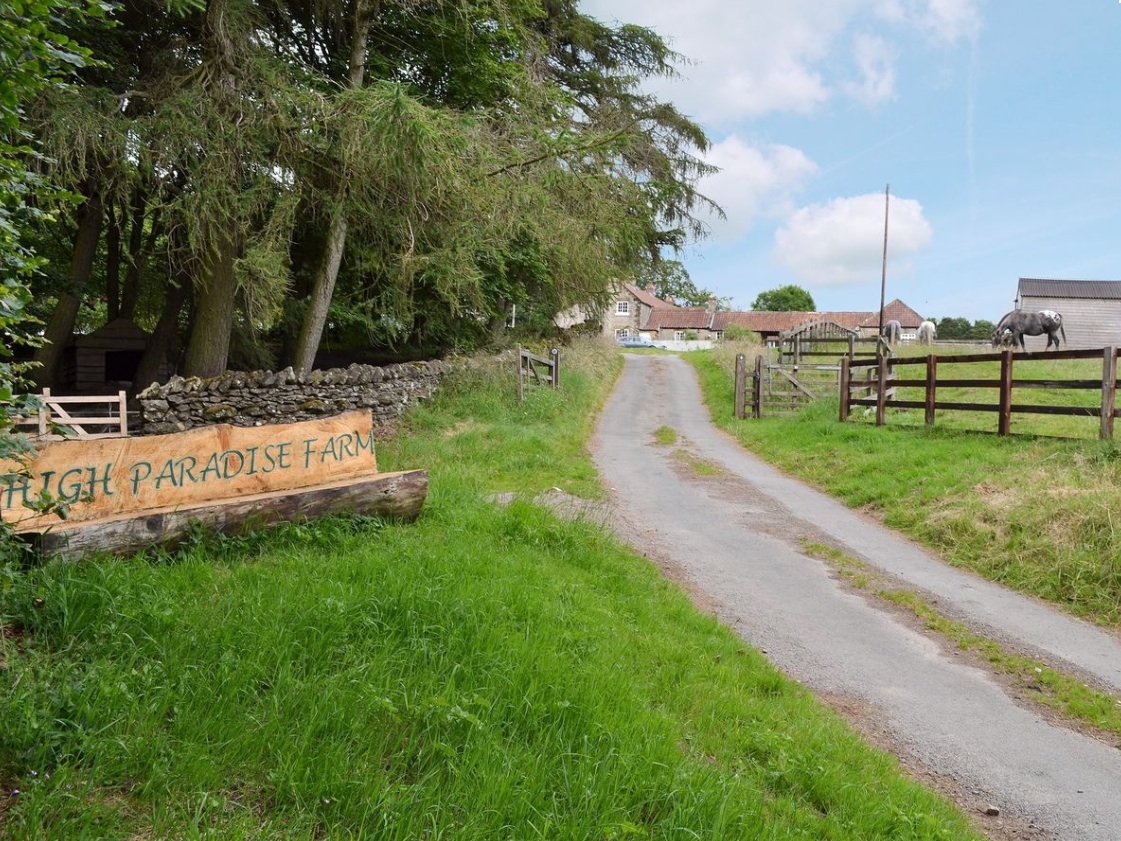
Service road into High Paradise Farm, Yorkshire

I was prompted to write this because of a few discussions over the last couple of months - people talking about the default tags on various OSM elements, reactions to Amazon mappers’ additions of “last mile” service roads and discussions about how to tag England and Wales’ public rights of way network.

This is very much a personal view and one that’s very “England and Wales” centric - there are lots of different approaches to rural tagging in general and footpath tagging in particular, and many places around the world (enlightened places like Scotland and Scandinavia) have different default access rights to the curious set we have ended up with in England and Wales.

Let’s start with an example - what’s the reasoning for the tags on this way in OSM?

Firstly - “highway=service”. That’s simply the physical type of highway that it is most like. Functionally it offers access to the farm and other businesses. Maybe people might argue it should have a driveway tag; maybe someone might think it was a paved track, but service is what it’s been in OSM for 9 years and it’s near enough for me not to change it.

Next, “designation=public_bridleway”. Where does that come from? The answer, I think is roughly here back in 2009. That thread (and parallel ones on talk-gb at the time) discussed how to tag a thing that’s legally one thing, but physically a bit like something else as well, very similar to “my” service road. The source for me to add the tag here was “Public Bridleway” signs along the route.

Next, the basic access tags - “foot=yes”, “horse=yes” and “bicycle=yes”. These say that you’ve got a legal right to walk, cycle or ride a horse up here - they’re also implied by the “Public Bridleway” signs. To an extent it makes sense in OSM not to have duplicate tags for things (it’d be a pretty unusual “highway=motorway” that needed “motor_vehicle=yes”), but it’s not really fair on routers that have to work internationally to expect them to know every nuance of “designation” tagging (which in this case doesn’t even apply to a whole country).

So far, that’s pretty close to the National Trust’s proposed public right of way (PRoW) tagging here. There’s one difference - they’d suggest “=designated” instead of “=yes” on the access tagging, so it’s looking at where that came from. There’s a discussion about the use of those keys in the context of England and Wales PRoWs here.

The reason I’ve not gone with “=designated” on this service road is that it has it’s own meaning documented here - think of a sign people of transport mode X to use a particular route. An example of this is here near Sheffield - there’s a poorly-signed public foootpath across the road there, but signage diverting pedestrians along the road via the roundabout (playing human frogger on a dual carriageway is not a good idea). The usage of “=yes” vs “=designated” on “designation” ways varies around England and Wales. Compare here (roughly the same number of each) with here (hugely in favour of “=designated”).

Other tagging would also make sense, such as a surface tag on the service road (I added one here but forgot further on), but there’s always the option to add more detail later.

Returning to one question from the start of this diary entry - do Amazon mappers’ additions additions of “last mile” service roads cause a problem? Imagine if someone added a track or driveway between two public roads that wasn’t public - wouldn’t it confuse people into thinking that there was a public route between the two when there really wasn’t? I’d argue not really, since without access tags you simply can’t assume (in England and Wales) that you have access along a track or driveway, even on foot. Where people have mapped access properly it’s easy to see where you know you definitely can go and where you’re not sure, and someone can always add access tags later - OSM has always progressed incrementally like that. This is if you’re using a map that shows it, of course but since 2009 I’ve always used e.g. Garmin maps that do.

Best Regards,

Andy


OpenStreetMap-Carto release v4.24.0

Dear all,

Today, v4.24.0 of the OpenStreetMap Carto stylesheet (the default stylesheet on the OSM website) has been released. Once changes are deployed on the openstreetmap.org it will take couple of days before all tiles show the new rendering.

Changes include:

  • Create darker river-color for river & canal areas and waterway lines (#3930)

The col

Dear all,

Today, v4.24.0 of the OpenStreetMap Carto stylesheet (the default stylesheet on the OSM website) has been released. Once changes are deployed on the openstreetmap.org it will take couple of days before all tiles show the new rendering.

Changes include:

  • Create darker river-color for river & canal areas and waterway lines (#3930)

The color of river, canal, ditch and drain waterway lines and river and canal areas is changed to #8fcadd (Lch78,21,227)

  • Fix rendering of water body labels (#3919)

Restores rendering of water body labels on points (node features) Fixes rendering of natural=bay to use italic font at all z levels Cleans up duplicate natural=strait code in water.mss

  • Precedence of junctions over POIs (#3915)

Junction=yes, =motorway and man_made=bridge labels now render before amenity-points This prevents icons from blocking the display of these text labels

  • Remove rendering of waterway=wadi (#3931)

The tag waterway=wadi is deprecated, suggested replacement: waterway=river/stream + intermittent=yes OR natural=valley

  • Move parking to amenity-points layers, change way_pixels limit and initial zoom level (#3923)

Moved parking features back to amenity-points layers Changed parking text intial zoom to z14, as planned in PR #3612 Change way_pixels limit for parking icon (750) and text (3000)

  • Don’t use classes anymore (#3912)
  • Convert state & country layers to ST_PointOnSurface (#3920)
  • Convert addresses to use ST_PointOnSurface (#3898)
  • Apply bbox to part of “addresses” query (#3942)

The 4 changes above are needed to allow use of vector tiles ST_PointOnSurface is used to generate a point for labeling Classes are removed, replaced with the layer id

  • Documentation updates (#3911) & (#3910), Code clean-up (#3899) & (#3922)

Document inner line rendering, update docker documentation Clean-up text-placement / marker-placement, remove natural=marsh

Thanks to all the contributors for this release, including Adrian Piotrowicz (@nexces), a new contributor.

For a full list of commits, see https://github.com/gravitystorm/openstreetmap-carto/compare/v4.23.0…v4.24.0

As always, we welcome any bug reports at https://github.com/gravitystorm/openstreetmap-carto/issues

We would love to have new contributors who might be interested in solving some of the many open issues.


Сергей Синицын: «OSM — это больше, чем просто рисовать домики или дорожки. Это еще истории!»

♦ Сергей Синицын — кандидат биологических наук, который окончил психфак МГУ, но в итоге связал свою жизнь с видео-артом и работает с известной арт-группой AES+F и художницей Ириной Наховой. При этом он правит карту в OpenStreetMap. Зачем нужно рисовать дорожки, стоит ли приходить в сообщество и как OSM связан с интересными жизненными историями — обо всем этом он рассказал в интервью.

Сергей Синицын Сергей Синицын — кандидат биологических наук, который окончил психфак МГУ, но в итоге связал свою жизнь с видео-артом и работает с известной арт-группой AES+F и художницей Ириной Наховой. При этом он правит карту в OpenStreetMap. Зачем нужно рисовать дорожки, стоит ли приходить в сообщество и как OSM связан с интересными жизненными историями — обо всем этом он рассказал в интервью.

Editing OSM for the first time

Hello from Japan. Today ( technically yesterday ) is my first day of OSM.
I think this activity will make me know my local area.

Hello from Japan. Today ( technically yesterday ) is my first day of OSM.
I think this activity will make me know my local area.

Thursday, 24. October 2019

OpenStreetMap User's Diaries

Florianópolis

Moro na região continental de Florianópolis e realizei por anos edições e adições ao mapa do OSM. Mas ultimamente a quantidade de alterações irresponsáveis no mapa, beirando o vandalismo, é de quantidade e frequência tais que se passa muito mais tempo corrigindo o mapa e muito menos tempo melhorando o mapa. Então boa sorte aos colegas mapeadores que permanecerem no serviço.

Moro na região continental de Florianópolis e realizei por anos edições e adições ao mapa do OSM. Mas ultimamente a quantidade de alterações irresponsáveis no mapa, beirando o vandalismo, é de quantidade e frequência tais que se passa muito mais tempo corrigindo o mapa e muito menos tempo melhorando o mapa. Então boa sorte aos colegas mapeadores que permanecerem no serviço.


addr:county tag within Somerset

I’ve recently been going through Wellington and Taunton (in Somerset) to find addresses that didn’t have the tag addr:county=”Somerset”, aided by Overpass Turbo and adding the tag and value, so as to be consistent with other addresses in the area.

  • Overpass Turbo link for Taunton search: overpass-turbo.eu/s/Nqr
  • Overpass Turbo link for Wellington search: overpass-turbo.e

I’ve recently been going through Wellington and Taunton (in Somerset) to find addresses that didn’t have the tag addr:county=”Somerset”, aided by Overpass Turbo and adding the tag and value, so as to be consistent with other addresses in the area.


ВОПРОС: СГЕНЕРИРОВАННЫЕ СПУТНИКОВЫЕ СНИМКИ

Коллеги, кто-нибудь знает, есть ли стиль для мапника, мапбокса, или любой тулзы, хоть бы для османда, который бы имитировал бы спутниковые снимки?

Чтобы по данным осм генерировались бы тайлы, похожие на спутниковые снимки/аэрофотосьемку?

Коллеги, кто-нибудь знает, есть ли стиль для мапника, мапбокса, или любой тулзы, хоть бы для османда, который бы имитировал бы спутниковые снимки?

Чтобы по данным осм генерировались бы тайлы, похожие на спутниковые снимки/аэрофотосьемку?


OpenStreetMap Blog

Making it easier to join the OpenStreetMap Foundation

Joining the OpenStreetMap Foundation used to always require a membership fee (£15 per year, which you can pay by PayPal or bank transfer). However, if you are involved in the OpenStreetMap project, and cannot pay this membership fee, it can be waived. Some OSMers live in a country under economic sanction/embargo (and thus without PayPal). […]

Joining the OpenStreetMap Foundation used to always require a membership fee (£15 per year, which you can pay by PayPal or bank transfer). However, if you are involved in the OpenStreetMap project, and cannot pay this membership fee, it can be waived. Some OSMers live in a country under economic sanction/embargo (and thus without PayPal). Others are in nations where the bank transfer costs themselves exceed the cost of membership. Others live under circumstances where this fee alone would constitute a substantial personal financial hardship. One of the main reasons for the Membership Fee Waiver program, is a wish to be more representative of mappers from around the world.

To address this, the Fee Waiver Program was created, which, for those who qualify, will grant an Associate Membership in the Foundation at no cost, subject to annual renewal.

Some reasons to join the OSMF

As a member of the Foundation you can influence the future direction of the project by

  • participating in the discussions between members and by
  • voting in the annual OSM Foundation elections for the board that steers the project.

Without being a member you can still edit OpenStreetMap, by creating a free account at https://www.openstreetmap.org and help the Foundation by joining one of the Working Groups.

Eligibility

Currently you are eligible to apply for a fee waiver if:

  • You are an active mapper, and are from a country which lacks suitable money transfer.
  • You are an active mapper, and paying the membership fee would present an unreasonable burden to you because of financial hardship

Please note that there might be changes after the 2019 Annual General Meeting.

Languages

You can apply in a language other than English.

Where to find more information

Please read the Fee Waiver manual on the OSM wiki, to find out how to fill the forms, the procedure and the links to the forms.

How to help

If you are interested in helping more people from your community become members of the Foundation, please:

Thank you.

Membership Working Group

The fee-waiver program has been developed under the Board’s direction by the volunteers of the Membership Working Group, with particular thanks to Joost Schouppe, Michael Spreng and Steve Friedl who have kept up the regular work with the Registrar.


Do you want to translate this and other blogposts in your language..? Please send an email to communication@osmfoundation.org with subject: Helping with translations in [your language]

The OpenStreetMap Foundation is a not-for-profit organisation, formed in the UK to support the OpenStreetMap Project. It is dedicated to encouraging the growth, development and distribution of free geospatial data for anyone to use and share. The OpenStreetMap Foundation owns and maintains the infrastructure of the OpenStreetMap project, is financially supported by membership fees and donations, and organises the annual, international State of the Map conference. It has no full-time employees and it is supporting the OpenStreetMap project through the work of our volunteer Working Groups. Please consider becoming a member

Wednesday, 23. October 2019

OpenStreetMap User's Diaries

Understanding How Others Map Roads and Rivers

Today was the usual mapping of buildings. When I went to upload these changes, however, quite a few warning signs came up regarding “tertiary road crosses river”. Usually only a few come up so I can click “ignore this issue” but today there were too many signs to ignore.

I can’t move or delete these rivers as I lack the knowledge on where these rivers run, and I also lack the geographica

Today was the usual mapping of buildings. When I went to upload these changes, however, quite a few warning signs came up regarding “tertiary road crosses river”. Usually only a few come up so I can click “ignore this issue” but today there were too many signs to ignore.

I can’t move or delete these rivers as I lack the knowledge on where these rivers run, and I also lack the geographical knowledge to predict where these rivers might run underground, if at all (I don’t move the roads as I can see them and know that they’re in the correct positions). I also don’t know where the mappers of these rivers got their information regarding the locations of the rivers underground unless it was first-hand knowledge from out in the field. If so, it begs the questions as to why there is a lack of labels on buildings nearby the rivers.

Perhaps this issue of roads and rivers crossing is something that mappers already look into at the validation stage. For what it’s worth, I have insufficient experience to be a validator as of yet. All in all I think it is a minor issue, but definitely something that should be looked into after the main bulk of a location is mapped.


My first time in OSM

Hello!

My namne is Matilda and I’m working with OSM in school. It’s going pretty good here. Just a lot to learn and practice.

XOXO SWEDISH GIRL

Hello!

My namne is Matilda and I’m working with OSM in school. It’s going pretty good here. Just a lot to learn and practice.

XOXO SWEDISH GIRL


My Osm experience

Hi! My name is Daniella and I am working with Osm in school! I think it’s a good and quite easy site that everyone can use.

Hi! My name is Daniella and I am working with Osm in school! I think it’s a good and quite easy site that everyone can use.


ДАННЫЕ OSM В X-PLANE

Как данные Openstreetmap используются в X-plane? Зачем обозначать дома? Для чего обозначать тип зданий?

Смотрите видео: www.youtube.com/watch?v=LzmRKjkiRMc

Миниатюра видео

Как данные Openstreetmap используются в X-plane? Зачем обозначать дома? Для чего обозначать тип зданий?

Смотрите видео: https://www.youtube.com/watch?v=LzmRKjkiRMc

Tuesday, 22. October 2019

OpenStreetMap.de

Wochennotiz Nr. 482

08.10.2019-14.10.2019 Die Abstimmung zum Proposal „Utility Markers“ läuft bis zum 26.10.2019 1 | Bild: Pyrog, Wikimedia Commons, CC-BY-SA 4.0 International Mapping Das MapRoulette-Team kündigt auf Twitter die Verbesserung der Dokumentation an. Sie sind auch auf der Suche nach Freiwilligen und … Weiterlesen →

08.10.2019-14.10.2019

lead picture

Die Abstimmung zum Proposal „Utility Markers“ läuft bis zum 26.10.2019 1 | Bild: Pyrog, Wikimedia Commons, CC-BY-SA 4.0 International

Mapping

  • Das MapRoulette-Team kündigt auf Twitter die Verbesserung der Dokumentation an. Sie sind auch auf der Suche nach Freiwilligen und Feedback.
  • Frederik Ramm fragt nach Meinungen zu „Mikroparks“, um sich in der Vermittlung in einem Streit in den USA eine Meinung bilden zu können.
  • Michael Brandtners Vorschlag, bei allen Rewe-Supermärkten ein cash_withdrawal= automatisiert zu ergänzen, stößt im Forum und auf der Mailingliste nicht nur auf Zustimmung.
  • John Kennedy veröffentlichte ein JOSM Plugin namens „RelationDissolve“, um die Erstellung neuer Grenzen von denen, die bereits in OpenStreetMap vorhanden sind, zu vereinfachen. Beim Zusammenführen bestehender Grenzen löst es automatisch alle gemeinsamen Grenzen auf.
  • Im deutschen Forum wird darüber diskutiert, ob Konventionen für das Kartieren von landuse=residential nötig sind. Anlass ist ein Fall, in dem landuse=grass für private Gärten verwendet wird.
  • Die Abstimmung über den Vorschlag von ChameleonScales für amenity=toy_library, eine Bibliothek, die nur Spiele und Spielzeug, aber keine Bücher verleiht, wurde gerade begonnen. Die Abstimmungsperiode endet am 27. Oktober 2019.
  • [1] Fanfouers Vorschlag zur Erfassung von Markierungen der Versorgungsnetze wie Wasserleitungen, Stromleitungen, Hydranten usw. steht bis zum 26.10. zur Abstimmung.

OpenStreetMap Foundation

  • Michael Reichert fragt den OSMF-Vorstand, warum die Microgrants ohne Rücksprache mit der Community implementiert wurden und erhält eine Antwort von Joost Schouppe.
  • Ein Protokollentwurf für die Sitzung der Local Chapters Working Group am 9. Oktober 2019 wurde im OSMF-Wiki online gestellt.

Veranstaltungen

  • Ilya Zverev bittet Mapper, einen Fragebogen zu den regionalen Mapping-Unterschieden auszufüllen. Er wird das Ergebnis auf der nächsten lokalen SotM-Konferenz vom 25. bis 27. Oktober in Prizren, Kosovo, vorstellen.
  • Imagico schrieb einen ausführlichen persönlichen Bericht über die State of the Map 2019 in Heidelberg.
  • Am 29. Oktober findet das 5. Vienna Geo Meetup statt. Dort können sich Interessierte aus dem GIS-Bereich untereinander austauschen. Es sind auch diesmal wieder Impulsvorträge geplant, die zu weiteren Diskussionen anregen sollen.
  • Am 12. Oktober fand in Moskau erstmals der Mapathon Missing Maps statt. Er wurde von Ärzte ohne Grenzen gemeinsam mit der Organisation „Gewächshaus der sozialen Technologien“ veranstaltet. 36 Teilnehmer erfassten in 2,5 Stunden 86% der Karte der Provinz Beitbridge im südlichen Teil von Simbabwe.

Humanitarian OSM

  • Zur Feier des Internationalen #DisasterRiskReduction-Tags am 13. Oktober veröffentlichte die GIScience Research Group der Universität Heidelberg einen Blogeintrag über die Tools, die sie für die humanitäre Hilfe während und vor Katastrophen entwickelt haben, und über die Ressourcen, die sie für Workshops, Konferenzen und Mapathons oder Forschung und damit verbundene Aktivitäten bereitstellen können.

Ausbildung/Schulung

  • kaggle.com bietet einen kostenlosen Kurs mit dem Titel Geospatial Analysis an. Der 5-stündige Kurs beinhaltet Lektionen über GeoPandas, eine Bibliothek für die Arbeit mit Geodaten in Python, Koordinatensysteme, interaktiven Karten, Geodatenmanipulation und Proximity-Analysen.

Karten

  • Es gibt fast für jeden Zweck eine Karte. Daher gibt es eine auch OSM-basierte Karte, die Motorradfahrern dabei helfen soll, einen Parkplatz zu finden.

switch2OSM

  • 115.бел, eine Website zur Meldung von Problemen mit öffentlichen Einrichtungen und Plätzen in Weißrussland, wurde aktualisiert (ru) (automatische Übersetzung). Bürger und Gemeinden können Störungen an Straßen, Radwegen, Straßenbeleuchtung usw. melden und erhalten eine Antwort von der Gemeinde oder der zuständigen Hausverwaltung. OpenStreetMap wird als Hintergrundkarte verwendet, und die Adressdaten scheinen von OSM zu stammen.

Lizenzen

  • Facebooks Attributierung von OSM-Daten – oder das Fehlen von davon – führt zu Diskussionen auf der OSMF-Mailingliste. Während einige Konsequenzen für die andauernde Verletzung unserer Lizenz sehen wollen, verweisen Frederik Ramm vom OSMF-Vorstand sowie Simon Poole von der License Working Group auf den Entwurf der Attribution Guidelines, die hoffentlich bald verabschiedet werden soll.

Programme

  • Andreas Bürki fragt auf der Mailingliste Talk-ch, warum skuettel.ch auf umap.osm.ch ein Drittanbieter-Cookie bei den Seitenbesuchern setze. Ursache sind die Beispielkarten auf der Startseite, die eigentlich ein Sicherheitsproblem sind.

Programmierung

  • Brian DeRocher überraschte die OSM-Entwickler mit einem großen Pull-Request, um „Microcosms“ auf der OSM-Website einzufügen. „Microcosms“ soll ein Feature werden, um lokale Mapper-Gruppen und deren Events zu unterstützen.

Kennst du schon …

OSM in der Presse

  • Im Blog gpsradler.de wird der Bryton Rider 860, ein GPS Navigationgerät der gleichnamigen Firma aus Taiwan, vorgestellt. Als Karte ist OpenstreetMap auf dem Gerät vorinstalliert.
  • Pokémon Go konnte auf der griechischen Insel Salamis nicht gespielt werden. Die ganze Insel war mit natural=bay gekennzeichnet, so dass das Spiel sie so behandelte, als wäre es Meerwasser. Während dies in OSM korrigiert wurde, hat Niantic (Entwicklungsfirma von Pokemon Go) die Daten noch nicht importiert und interpretiert sie weiterhin als Wasser. Die Reaktion des Entwicklers auf den Reddit-Thread, der das Problem zur Sprache brachte, hat Hoffnungen auf eine Lösung geweckt (via Eurogamer).

Weitere Themen mit Geo-Bezug

  • The Guardian berichtet über ein Projekt, bei dem alle Landstriche der Erde aus der Luft mit einem Laser gescannt werden sollen, um die kulturellen, ökologischen und geologischen Schätze der Welt zu dokumentieren und zu erhalten. Die resultierende 3D-Karte mit einer Auflösung von 20 cm wird geschätzte 15 Mio. USD kosten.
  • Chris Fleet berichtet in seinem Paper Creating, Managing, and Maximising the Potential of Large Online Georeferenced Map Layers über das Georeferenzierungsprogramm und die Nutzungsangebote der historischen Kartensammlung der Schottischen Nationalbibliothek, die Ihre Bestände auch der OSM-Community zur Verfügung stellt.
  • Die Website Geospatial World hat einen Artikel über die Entwicklung von Google Maps veröffentlicht. Obwohl der Artikel bis in das Jahr 2005 zurückgeht, als Google seinen Kartendienst startete, enthält der Artikel nicht sehr viele Details.
  • Pacific Gas & Electric stellte Shapefiles anstelle einer funktionierenden Karte für Stromabschaltungen im Vorfeld von Brandmeldungen in Kalifornien zur Verfügung. Dies wurde kritisiert, aber der San Francisco Chronicle hat mit dem Faltblatt eine benutzerfreundliche slippy map erstellt. Die Stromausfälle betrafen mehr als 1 Million Menschen und folgen dem tödlichen Waldbrand des letzten Jahres, der auf Störungen an Stromleitungen zurückzuführen war.
  • Die Website Mongabay veröffentlichte einen Kommentar von Pratyush Tripathy, in dem er über die Verwendung von Sentinel-1-Satellitenbildern zur Kartierung des Ausmaßes der jüngsten Überschwemmungen in Assam und Bihar, Indien schreibt. Die Ergebnisse wurden auf nicht attributtierten OSM-Karten präsentiert und sollen ein Beispiel dafür liefern, wie solche Karten bei Rettungsmissionen helfen können.
  • Geoscience Australia hat angekündigt, ab Dezember 2019 keine topografischen Karten mehr zu drucken und zu verkaufen.
  • pocketnavigation.de testet intensiv das „all Terrain Navi“ Garmin Overlander, Ein Offroad-Navi für schwere Fahrzeuge abseits der normalen Straßen. OSM ist vorinstalliert.
  • Die Massey University Press hat „Why We are Here“ veröffentlicht. Dabei handelt es sich um einen thematischen Atlas Neuseelands (Māori: Aotearoa) von den Autoren Chris McDowell und Tim Denee. Von besonderem Interesse für Kartenliebhaber ist, dass einige Notizen, Daten, Code (Python, R) und Style Sheets (Mapnik) auf ihrer GitHub-Seite veröffentlicht wurden.

Wochenvorschau

Wo Was Wann Land
Berlin Missing Maps Mapathon – Putting the Wolds’s Vulnerable People on the Map 2019-10-17 germany
Vienna 63. Wiener Stammtisch 2019-10-17 austria
Karlsruhe Karlsruhe Hack Weekend 2019-10-19-2019-10-20 germany
Lübeck Lübecker Mappertreffen 2019-10-24 germany
Rapperswil 11. Micro Mapping Party Rapperswil (OpenStreetMap Mapathon) 2019-10-25 switzerland
Bremen Bremer Mappertreffen 2019-10-28 germany
Düsseldorf Stammtisch 2019-10-30 germany
Ulmer Alb Stammtisch Ulmer Alb 2019-10-31 germany
Stuttgart Stuttgarter Stammtisch 2019-11-06 germany

Hinweis:
Wer seinen Termin hier in der Liste sehen möchte, trage ihn in den Kalender ein. Nur Termine, die dort stehen, werden in die Wochennotiz übernommen. Bitte prüfe die Veranstaltung in unserem öffentlichen Kalendertool und korrigiere bitte die Einträge im Kalender, wenn notwendig.

Diese Wochennotiz wurde erstellt von Map-Peter, Nakaner, Rainero, Rogehm, SunCobalt, TheSwavu, derFred, doktorpixel14, geologist, anonymus.


OpenStreetMap User's Diaries

State of the Map 2019: Journey of Creation to Use

My journey with OpenStreetMap (OSM) started unofficially after the 2015 Nepal Earthquake. During this time I experienced the real impact of the use of OSM data by humanitarian agencies in Sindhupalchok—the second most devastated district after the earthquake. After the earthquake for immediate and effective response, the Government of Nepal, National Planning Commission and Himalayan Climate Ini

My journey with OpenStreetMap (OSM) started unofficially after the 2015 Nepal Earthquake. During this time I experienced the real impact of the use of OSM data by humanitarian agencies in Sindhupalchok—the second most devastated district after the earthquake. After the earthquake for immediate and effective response, the Government of Nepal, National Planning Commission and Himalayan Climate Initiatives’ collective established National Volunteering Program (NVP). I lead the initiative as the national coordinator. As soon as I came back to Kathmandu, I start following mapping work and got introduced to Dr. Nama Raj Budhathoki who was leading the mapping initiative with national and international digital mappers. Later, KLL became one of the co-implementation partners of NVP.

On 27 Oct 2016, I got my account on OSM and started contributing to my best ability on point, line, and polygon. My interest in OSM grew so much that I decided to leave NVP and join KLL to lead the community of OSM Nepal representing KLL. Thanks to the mentorship of Dr. Budhathoki and the team at KLL, I got involved with community expansion by sensitizing around 3000 new people about OSM by visiting various schools, colleges, conferences, and institutions. It was a proud moment for me and KLL that we were able to introduce the first and second cohort of Digital Internship and Leadership Program (DIAL) which was very successful for both quality and quantity contribution to OSM. It was another proud moment to represent the OSM Nepal community to host the 2017 State of the Map Asia conference in Nepal as one of the organizers which were a grand success. The journey with OSM in 2016, 2017, and early 2018 remained more as a contributor on a daily basis whereas the post-2018 is focused on the use of it.

I shortly started my own venture, the Youth Innovation Lab–a not for profit civic tech company in late 2017 and started working on various initiatives using OSM data. The first product that we developed from YI-Lab was mahilapratinidhi.com that uses some layers of OSM. Our second product became revolutionary when we started working with the Government of Nepal, Ministry of Home Affairs on Integrated Disaster Information Management System (DIMS) which is locally named as Building Information Platform Against Disaster (BIPAD). BIPAD was developed to harness the use of Open Data in a Government portal to advance data-based decision making and disaster response. In a six-module platform, the role of Open Data has been instrumental to support each component of incident reporting to risk-related information. This innovation also led to the prestigious Global Resilience Partnership (GRP) mini award and Yi-Lab’s representation to Global Partnership on Disaster Risk Reduction Conference (GPDRR) 2019 in Geneva, Switzerland.

As being closely associated with OSM, it was a proud moment to receive a scholarship as a scholar to attend and speak at the State of the Map (SotM) 2019. This opportunity gave me a chance to meet people with different backgrounds but a common passion for OSM from around the globe. It was great to see how OSM is being helpful all over the world to bridge the

data gap in solving the most critical issues around. It has been great to see initiatives developed based on OSM to solve problems of food and nutrition in Africa, the tools used in mapping hurricane in Asia to the transportation offline app is useful for the Government in transportation navigation—there were dozens more.

The weather of Heidelberg and Kathmandu is pretty similar regardless, it was a little challenging for me to cope up with the environment. But the sessions were so interesting that I possibly could not have missed any of those, be it planned indoor/outdoor or as a social gathering after the session. I was also able to hang out with my friends in the beautiful city of Heidelberg and explore the beauty of ancient civilization that still stands out as the most attractive tourist destination. Attending this conference, I received a lot of ideas and collaboration requests from different Open Data and OSM enthusiasts to work together in each other’s intervention.

Meanwhile, I am reaching out to them to establish a productive partnership and to take the idea of co-working forward. I can proudly say that attending SotM 2019 was one of the best things that I did in 2019. After the conference, I also managed to extend my travel and visit some of the European countries like Spain, France, Belgium, which added more fun to my visit. I am determined that I will keep continuing my efforts to make the OSM community strong and will be guiding more people to join this network and contribute to OSM. I will also make use of my learnings from SotM 2019 in my work and for the sensitization among fellow OSM contributors.


Школьный урок по OpenStreetMap

На прошлой неделе меня по работе отправили в Бобруйск. Это такой большой маленький город, где делают вкусный ирис, а с недавних пор мы в Juno Lab помогаем там делать умных школьников. Рассказывал, как обычно, про OpenStreetMap. Пришлось много тренироваться, чтобы дети смогли высидеть полтора часа и не заскучать. Разумеется, стоило им открыть iD, как их школа пропала с карты — но затем

Илья показывает на слайд «OpenStreetMap»

На прошлой неделе меня по работе отправили в Бобруйск. Это такой большой маленький город, где делают вкусный ирис, а с недавних пор мы в Juno Lab помогаем там делать умных школьников. Рассказывал, как обычно, про OpenStreetMap. Пришлось много тренироваться, чтобы дети смогли высидеть полтора часа и не заскучать. Разумеется, стоило им открыть iD, как их школа пропала с карты — но затем появилась, заново нарисованная.

Чтобы результат не пропал, повторил весь текст на камеру. Сорок минут отборной картографии. Теперь есть что присылать людям, которые не знают про OpenStreetMap, а вам лень объяснять:

https://www.youtube.com/watch?v=469pkgFDYhk


China 2020

dreaming my life away,,,

dreaming my life away,,,


should everything be grouped into one mega relation

so then other osm programs can use all the stuff to add to their own site.

so then other osm programs can use all the stuff to add to their own site.

Monday, 21. October 2019

OpenStreetMap User's Diaries

Sight Safari - поиск интересных пешеходных маршрутов теперь и на Android

Наш пешеходный навигатор обзавелся Android версией. Да, это еще один Android навигатор по OSM данным, но с уникальной фичей - он ищет не кратчайшие, а наиболее интересные для пешехода маршруты, идущие мимо парков, памятников и дворцов.

Кроме прямых маршрутов между двумя точками можно строить круговые, с возвратом назад за указанное время. Ну вот есть два часа до поезда, далеко от вокзала

Наш пешеходный навигатор обзавелся Android версией. Да, это еще один Android навигатор по OSM данным, но с уникальной фичей - он ищет не кратчайшие, а наиболее интересные для пешехода маршруты, идущие мимо парков, памятников и дворцов.

Кроме прямых маршрутов между двумя точками можно строить круговые, с возвратом назад за указанное время. Ну вот есть два часа до поезда, далеко от вокзала не уйдешь, а посмотреть что-то интересное поблизости хочется.

Скрин из Play Market Скрин из Play Market

Раньше писал уже тут про идею алгоритма.

Уже есть 100+ городов России и мира, благодаря OSM новые добавлять можно в пару кликов.

Кому интересно - скачивайте, пользуйтесь, все бесплатно и без рекламы. Ссылка на приложение в Play Market


Add this location in the map

Haji Ali Muhammad Rahu

Haji Ali Muhammad Rahu


Studiu la faţa locului în cartierul Tractorul şi pe Drumul Poienii

…pe Strada Gloriei şi jumătatea dinspre Strada Bronzului a Străzii 1 Decembrie 1918, precum şi în cartierul Belevue Residence, pe Strada Stejarului, pentru adăugare numere la blocuri.

…pe Strada Gloriei şi jumătatea dinspre Strada Bronzului a Străzii 1 Decembrie 1918, precum şi în cartierul Belevue Residence, pe Strada Stejarului, pentru adăugare numere la blocuri.


Studiu la faţa locului pe Strada Lacurilor şi Strada Ioan Meşotă

…pentru adăugare numere la blocurile adiacente, efectuat ieri 20 octombrie 2019.

…pentru adăugare numere la blocurile adiacente, efectuat ieri 20 octombrie 2019.


Experiência no SotM 2019

Quando pensei em acompanhar 4 jovens portugueses, numa mobilidade Erasmus+, a Heidelberg, com mais um colega professor e participar no State of the Map 2019, considerei que deveris ser interessante, mas que para alguém das áreas das TIC ou da Geografia deveria ser MESMO fantástico. Para mim, alguém das literaturas, seria mais uma etapa de aprendizagem, como todas as que se relacionam com o nosso

Quando pensei em acompanhar 4 jovens portugueses, numa mobilidade Erasmus+, a Heidelberg, com mais um colega professor e participar no State of the Map 2019, considerei que deveris ser interessante, mas que para alguém das áreas das TIC ou da Geografia deveria ser MESMO fantástico. Para mim, alguém das literaturas, seria mais uma etapa de aprendizagem, como todas as que se relacionam com o nosso maravilhoso projeto, EuYoutH OSM. Estava enganada, redondamente enganada… Foi, para quem gosta de aprender, das experiências mais ricas e profícuas que já abracei. em 3 dias de SotM 2019 interagi pessoas oriundas de: Colômbia, Nicarágua, Bolívia, Estados Unidos da América, França, senegal, Burundi, Burkina Faso, Canadá, Alemanha, Espanha, Irlanda, Roménia; Uganda, Japão, Togo, Turquia, Hungria, Tanzânia, Madagáscar, Guiné-Conacri, Croácia, Brasil, Itália, Inglaterra, Escócia, Congo, Índia, Bélgica… Acho que não me esqueci de nenhum… Trocámos ideias, pontos de vista e alargamos a nossa mundividência. Falar do SotM e não falar das conferências, não faria sentido. Se quiserem ler sobre a perspetiva de quem gosta do OSM, mas não é perita em OSM, aui vai: umas conferências foram mais técnicas, outras tão acessíveis, como foi o caso da de Pierzen ou de Manfred Reiter… Em todas entrei uma e saí outra, saí mais rica. A organização foi excelente, tudo a horas, com boas condições técnicas e físicas. Um sucesso! E, de repente, dei por mim, no meio de tanta gente tão diferente, de tantas latitudes e longitudes e a pensar: “eu tenho tanta sorte de fazer parte deste grupo de gente que partilha comigo a ideia fulcral do OSM - o conhecimento é feito por todos e para todos!”. Por último, tenho de acabar esta pequena reflexão, agradecendo ao meu mentor OSM que, em boa hora, nos desafiou a participar no SotM 2019 e a crescer mais um pouco. Obrigada derFred.